Antalya
Area : 20.815 km²
Population : 1.719.751 (2000)
Traffic Code : 07
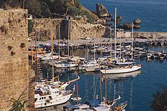
 Because of the archaeological and natural riches of the area, Antalya is also known as the Turkish Riviera. The sun, sea, nature and history combine to form a very popular resort, highlighted by some of the cleanest beaches in the Mediterranean. The 630km shoreline of the province is liberally scattered with ancient cities, harbours, memorial tombs and beaches, secluded coves and lush forests, many of which are easily accessible from the city.
With its palm-lined boulevard, internationally-acclaimed marina, and old castle with traditional architecture, all set amidst a modern city, Antalya is a major tourist centre in Türkiye. In addition to the wide selection of hotels, restaurants, bars, nightclubs and shops, the city also plays host to a number of sporting events throughout the year, like international beach volleyball, triathlon, golf tournaments, archery, tennis and canoeing competitions. The Cultural Centre, which opened in 1995, hosts cultural and art events in the fields of music, theatre, and creative arts. The main area of interest in the city is central old quarter within the Roman walls, known as Kaleici, and there are many good museums.
Districts: Akseki, Alanya, Elmali, Finike, Gazipasa, Gundogmus, Ibradi, Kale, Kas, Kemer, Korkutali, Kumluca, Manavgat and Serik are all towns in the province of Antalya.
Akseki
After Alanya, Akseki is the oldest district in the province of Antalya, and has an appearance that befits its location in the rugged Taurus mountains, in a forested and very rocky area. The history of Akseki extends back to the Roman era, when it was known as Marla (Marulya), and has been continually inhabited until the present day. The developments in the tourism sector in the Antalya region in recent years have been seen in Akseki as well. The area is well known for the snowdrop flower, and every years sees local and foreign visitors coming every winter to see these flowers breaking through the snow, as the first sign of spring.
In the Giden Gelmez Mountains, goats are protected and limited hunting is available around the year with the purchase of a license. Another spot frequented by visitors is the trout farming facilities in the villages of Sinan hoca and Gumusdamla. The primary game in the area is mountain goat, rabbit, bear and fox.
Other areas worth visiting are the Goktepe Highland, Giden Gelmez Mountains, Cimi Highland, Irmak Valley and the 340-metre deep Bucaklan Cave, which has only recently been discovered. Buildings of interest are the Ulu Camii and medreses.
Elmali
 The exact founding date of Elmali, which is located within the borders of ancient Lycia, is unknown. Excavations to the east at Karatas near the village of Semahoyuk, and to the west in the village of Beyler indicate that the area has been inhabited seen the Bronze Age.
Throughout history, it has suffered the rising and falling fortune of the Lycian region, being ruled respectively by the Persian, Greek, Roman, Byzantine, Seljuk and Ottoman empires.
Tumuluses: There are several tumuluses in nearby villages. The first is west of the city in the village of Mugren, on top of which sits a small fortress dating back to the Roman era. Surface-level archaeological research indicates that the area was inhabited in the Bronze Age by various civilisations. Another village in the west, Semahoyuk, has a tumulus but due to the fact that an Ottoman cemetery is located on top of it, no research has been done. The third and largest tumulus is in Beyler, south of the city on the Elmali - Kas road. Excavations conducted here, show that the area has been continuously inhabited from the Bronze Age right up to the present time. The items unearthed in the excavations are exhibited in the Antalya Museum.
At the east of the city 6 km from the village of Elmali near the village of Bayindir, there are several tumuluses side by side. Artifacts dating back to the 7th century BC were unearthed during the excavations. Now on display in a special section of the Antalya Museum, these findings represent a cross-section of life during that era. A statuette of pure silver and two of ivory bear witness to the fact that the art of sculpture in ancient Anatolia had reached a level of some sophistication.
Memorial Tombs: There are tombs in Karaburun and Kizilbel. The walls of the King's Tomb in Karaburun, on the Antalya - Elmali road, is decorated with frescoes of scenes of hunting and war. The tomb in Kizilbel is west of the city on the Elmali - Yuvayol road, and is a single room made of limestone blocks.
Define Described as the Treasure of the Century, this was discovered in 1984, just on the north of Antalya - Elmali road between the King's Tomb and the village of Gokpinar. Consisting of 190 pieces of ancient silver coins, the treasure was smuggled to America by antique treasure thieves. It is still on display in the Boston Museum of Fine Arts as part of a private collection. The Athens Decadrachme, 14 pieces each worth US$ 600,000, is said to be the world's most valuable treasure find.
Mosques The most interesting mosques in the area include Selcuklu Camii, Kutuk Camii, Sinan-i Ummi Camii, Omer Pasa Camii and medrese.
Korkuteli
Located 67 km from Antalya, Korkuteli is surrounded by Antalya on the east, Burdur on the north, Mugla on the southwest and Elmali and Kumluca on the south. The effects of the Mediterranean climate can be felt here in this region of lakes but the further one goes inland, the more continental the climate becomes with cold winters and hot summers.
The Alaaddin Mosque 3 km in the west of Korkuteli, only the door of which is still standing. In the same area is the Seljuk religious school which bears the name of its founder and was built by El Emin Sinaeddin of the Hamidogullari dynasty in 1319.
Gundogmus
There are numerous ruins of ancient cities in the district of Gundogmus, which is 182 km from Antalya. The important ruins are those of Hagiasophia city, 7 km north of Guzel Bag Bucagi, but no excavations have been conducted here. There are also the ruins of Asar at Sumene (7 km from the city centre), Kese (2 km east of the village of Senir) and Gedfi (11 km southwest of Gundogmus).
Other places to visit in the area include; Cem Pasa Camii; ruins on top of Sinek Mountain, 15 km east of the city centre between Gundogmus and Pembelik; and the ruins of Kazayir at Tasagir, on the Gundogmus - Antalya highway.
Gazipasa
Situated 180 km from Antalya, Gazipasa is a charming little town with a beach 10 km long, beautiful forests and turquoise blue coves. Iskele, the site of the Koru and Kahyalar beaches, is an important breeding ground of the caretta caretta turtles. Mostly undeveloped up until the present time, Gazipasa is on its way to being an attractive tourist centre with accommodation, recreation facilities, an airport and yacht harbour still under construction, as well as the natural and historical treasures of the area.
Antiocheia Ad Cragum 18 km east of Gazipasa, and within the village of Guney, these ruins gets its name from the Commagene King Antiochus IV, and are found on the three hills that stretch out towards the sea. It has the ruins of a castle dating back to the Roman and Byzantine era, a column-lined boulevard, agora, baths, victory arch, a church and the city necropolis. The barrel-vaulted memorial tombs with their pre-entrance porticoes are well preserved and reflect a style peculiar to the region.

Adanda (Lamos) This ancient city is located 15 km northeast of Gazipasa, and was founded 2 km north of the present-day village of Adanda, on the top of a high and steep hill. It is a walled city with a large tower south of the city gate, and among the ruins are a fountain carved into the living rock and two temples. Other significant ruins are the tombs in the necropolis made of single pieces of carved stone. These remains are a good representation of the culture and art of the mountainous Cilician region.
Nephelis This ancient ruin can be reached by going through the village of Muzkent 12 km out on the Gazipasa-Anamur road and taking the gravel road south for about 5 km. The southern area is surrounded by the sea and steep cliffs. The city consists of the acropolis and the remains of dwellings spread out in an east-west fashion. The only standing structures date back to the Roman and Byzantine periods and include a Medieval Castle, a temple, a musical hall, irrigation system and the necropolis.
Selinus Located on the slopes in southwest of Hacimusa Creek by Gazipasa Beach, the ancient city of Selinus is one of the most important cities in the mountainous Cilician region. On the top of the hill is the acropolis as well as the walls and towers of a medieval castle, which are fairly well preserved. In the Acropolis, a church and cistern have survived the ravages of time. The other buildings of Selinus are near the beach and on the slopes, among which are the baths, agora, Islami Yapi (mansion), aqueducts and the necropolis. Most of the bones in the Alanya Museum were brought from the Necropolis and allow the workshop in the museum to exist.
Kumluca
Situated on the plane formed by the silt carried down from the mountains by Alakir Creek and Gavur Brook, Kumluca is surrounded by the towns of Finike and Elmali. In the upper reaches of Alakir Creek fed by the springs coming from Onemli Mountains and the Beydaglar Mountains, there are trout and striped mullet.